Within Geometry
Did the UFO vanish or just pass behind something?
Terrain, buildings and cloud layers can explain disappearances, jumps and apparent drops that look strange from one viewpoint.
On this page
- Checking ridges, trees and buildings
- Cloud gaps and misleading motion cues
- Comparing multiple witness sightlines
Page outline Jump by section
Introduction
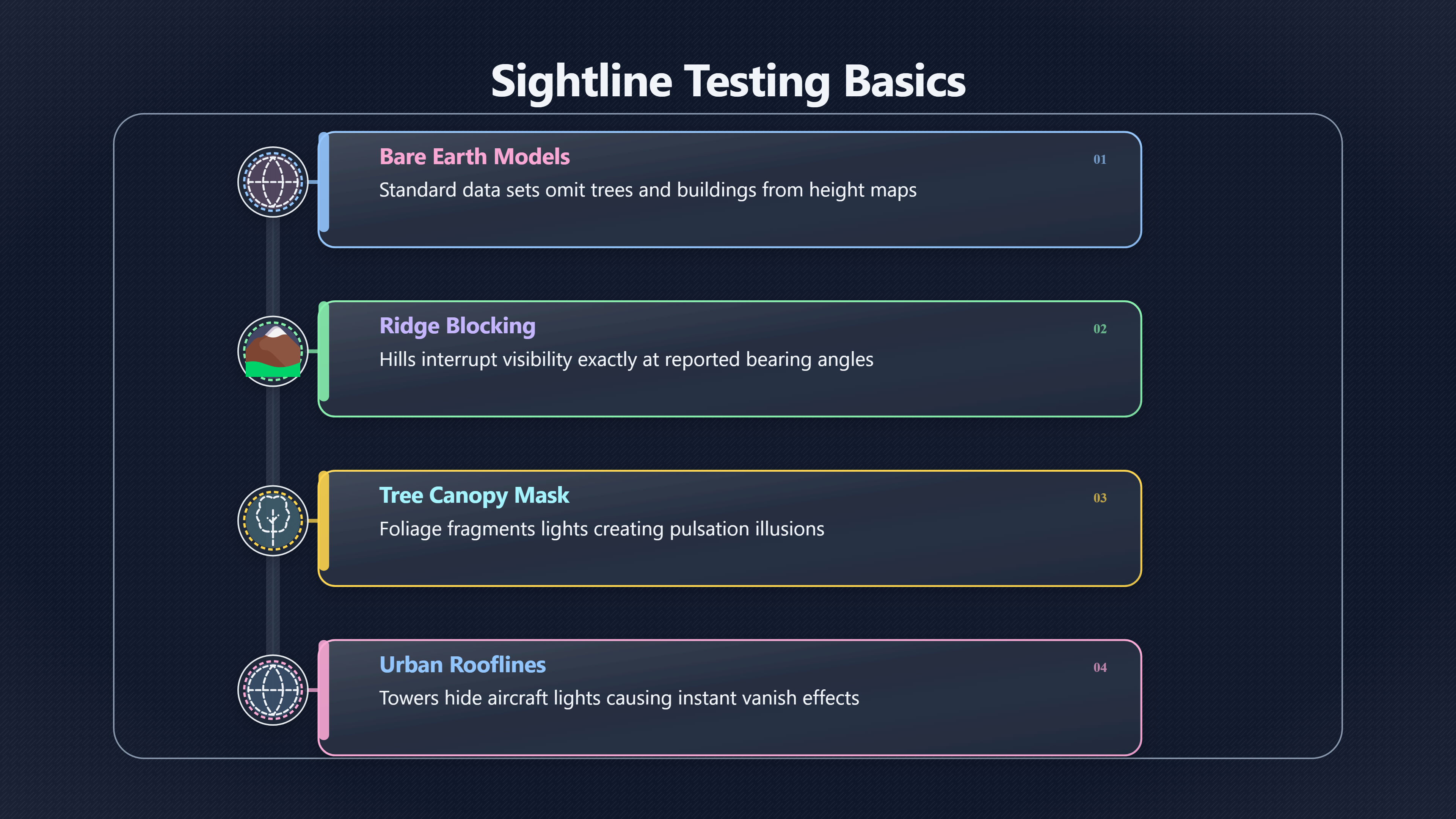
A surprising number of UFO reports depend on one hidden assumption: that the object stayed visible the whole time. In practice, hills, rooflines, tree cover and cloud layers can make ordinary aircraft, satellites, drones or astronomical objects appear to jump, stop, drop vertically or vanish outright. Sightline testing asks a simple question that often changes the entire case: could the witness actually see the object continuously from that location?
 This is where bearing and elevation checks become genuinely investigative rather than descriptive. Once a witness position, viewing direction and rough angle above the horizon are known, AI-assisted workflows can test the line of sight against terrain models, skyline profiles, weather data and cloud cover. The result is often more revealing than the object description itself. A “sudden disappearance” may align exactly with a ridge line. An apparent acceleration may coincide with a break in low cloud. Multiple witnesses may seem contradictory until their different viewing angles are reconstructed.
The aim is not to dismiss sightings automatically. Some reports survive these checks cleanly. But line-of-sight analysis is one of the fastest ways to separate unusual geometry from genuinely unusual behaviour.
Checking ridges, trees and buildings
A witness can only report what was visible from their exact position. Even small changes in elevation or viewing angle can radically alter what appears possible in the sky.
Modern investigations increasingly use digital elevation models, or DEMs, to recreate terrain around the observation point. These models represent the height of the ground surface and are widely used in geographic information systems for visibility analysis. [USGS]usgs.govUSGSWhat is a digital elevation model (DEM)?A Digital Elevation Model (DEM) is a representation of the bare ground (bare earth) topograph… [ArcGIS]doc.arcgis.comArcGISConduct line of sight analysis—3D Workflows | DocumentationA line-of-sight analysis in ArcGIS involves examining the visibility bet… A reconstructed sightline can then be traced outward from the witness position to see where hills, ridges or urban structures interrupt visibility.
This matters because many UFO reports contain phrases such as:
- “It dropped behind the hills”
- “It vanished instantly”
- “It reappeared further left”
- “It hovered over the ridge”
- “It dipped below the treeline”
Those descriptions sound dramatic until the geometry is tested. If an aircraft passes behind a ridge at exactly the reported bearing and elevation, the “vanishing” event may no longer require an exotic explanation.
Why horizon lines mislead witnesses
Human observers naturally treat the visible horizon as a flat reference. Real terrain almost never is.
A witness looking across a valley may see only the upper section of a distant aircraft because the lower fuselage is hidden behind terrain. From another location a few hundred metres away, the same aircraft could appear fully visible. This creates a common mismatch in UFO reports:
- one witness reports a hovering object
- another reports motion
- another says the object disappeared
All three may be describing the same object from different sightlines.
AI-assisted case reconstruction can compare these overlapping witness cones against terrain profiles. Viewshed analysis tools used in mapping and geospatial planning are designed for exactly this problem: determining what is visible from a given point and what is blocked. [GIS Geography]gisgeography.comLine of Sight vs Viewshed: Visibility AnalysisWhile line of sight determines obstructed and unobstructed on a line, a viewshed dictates s… [3ArcGIS 3ArcGIS]
Buildings and trees create “hard cut” disappearances
Urban sightings are especially vulnerable to misleading occlusion effects.
A distant helicopter or drone moving behind tower blocks can appear to extinguish instantly if its lights are hidden at the same moment. Likewise, aircraft on approach paths often disappear behind rooflines before reappearing through street gaps, creating the illusion of discontinuous movement.
Trees complicate sightings further because foliage creates partial masking rather than a clean obstruction. A blinking aircraft beacon seen intermittently through branches can resemble pulsation or erratic movement. In wooded areas, witnesses may also overestimate vertical motion because only fragments of the object remain visible between branches.
Investigators therefore try to reconstruct:
- witness eye height
- local slope angle
- surrounding structures
- seasonal foliage conditions
- whether the observer was moving
That last point matters more than many witnesses realise. A UFO viewed from a moving car can appear to “track” the observer while actually remaining stationary relative to distant terrain.
Why bare terrain models are not enough
Many elevation datasets model only the ground surface, excluding buildings and vegetation. USGS guidance on DEMs explicitly notes that standard bare-earth models omit trees and structures. [USGS]pubs.usgs.govdraft inventory analysis units for National Scenic…by SM Lindley · 2024 · Cited by 1 — The best practices herein are for creating draf…
That limitation matters in UFO investigation because witnesses rarely observe from empty landscapes. A technically correct terrain line may still produce a misleading result if:
- forest canopy blocks the view
- urban towers obscure part of the sky
- industrial structures interrupt the horizon
- local embankments or roadside cuttings are missing from the dataset
More advanced reconstructions therefore combine terrain elevation with lidar-derived surface data, aerial imagery or street-level mapping. In practice, investigators often discover that the decisive obstruction was not a mountain but a nearby row of trees.
Cloud gaps and misleading motion cues
Cloud layers are among the most underestimated causes of apparently impossible UFO movement.
Witnesses often assume the sky is a stable background. In reality, broken cloud can act like a moving mask. A light source passing behind uneven cloud edges may appear to:
- accelerate
- stop suddenly
- split into multiple lights
- dim and brighten
- reverse direction
- descend vertically
This is especially common at night, when observers lose stable visual references.
A stationary object can appear to move
One classic example involves bright planets or stars seen through drifting cloud gaps. The object itself remains fixed, but the moving cloud edge creates apparent motion. If the cloud layer is uneven, the object may brighten and dim irregularly, producing the impression of controlled manoeuvring.
Aircraft landing lights create a related effect. Seen head-on through low cloud, they may appear stationary for several minutes because the aircraft is flying toward the observer rather than across their field of view. Once the aircraft changes angle or enters thicker cloud, the light can vanish abruptly.
Cloud structure also distorts size perception. Thin haze can create large glowing halos around bright lights, while broken cloud can fragment a single source into multiple apparent objects.

Low cloud and hidden motion
Reports of “instant disappearance” frequently coincide with low cloud decks or hill fog.
A witness may continue tracking a bright light mentally even after it has entered cloud. When the light fails to emerge where expected, the brain interprets the loss as sudden disappearance rather than gradual obscuration.
Graphical aviation weather products are useful here because they preserve historical estimates of cloud layers, visibility and obstructions to vision. [aviationweather.gov]aviationweather.govSource details in endnotes. [2navcanada.ca]navcanada.caAVIATION WEATHER SERVICES GUIDELine of sight from radar within a limited horizontal range. Composite or… The Clouds and Weather GFA ch… If a witness reports a UFO dropping below cloud at 21:10, investigators can compare the estimated cloud base and local terrain height against the reported viewing angle.
Sometimes the geometry becomes surprisingly mundane:
- the object entered low stratus cloud
- the ridge line concealed the lower cloud edge
- the witness interpreted the fade-out as descent
The witness may still be reporting honestly. The interpretation changes because the atmosphere itself acted as a moving visual filter.
Clouds remove depth cues
The human visual system estimates motion partly by comparing objects against fixed backgrounds. Clouded skies remove many of those references.
Without visible stars, terrain edges or horizon detail, witnesses can dramatically misjudge:
- speed
- altitude
- distance
- acceleration
A small drone near the observer may look like a huge distant object. A distant aircraft emerging through cloud gaps may appear to dart across the sky because only fragments of the trajectory are visible at any one time.
This is one reason why UFO reports during overcast or partially overcast conditions require extra caution before assigning extraordinary interpretations.

Comparing multiple witness sightlines
Multiple witnesses do not automatically strengthen a UFO case unless their sightlines are geometrically compatible.
In some investigations, witness accounts initially appear contradictory:
- one observer reports a hovering object
- another reports fast movement
- another reports disappearance behind hills
- another says the object climbed vertically
Once mapped, however, the reports may align perfectly with a single aircraft track partly hidden by terrain and cloud.
Triangulation is often less precise than people assume
Popular culture treats multiple witnesses as equivalent to triangulation. Real-world witness geometry is usually much messier.
For accurate triangulation, investigators need:
- precise observer locations [doc.arcgis.com]doc.arcgis.comYou specify the observer locations you are interested in, either from a dataset or interactively…
- synchronised timing
- reliable bearings
- reliable elevation estimates
Most civilian sightings lack at least two of those elements.
AI-assisted workflows therefore model uncertainty corridors rather than precise rays. A witness who says “south-west and fairly high” produces a broad cone, not a laser-accurate vector. Overlapping those uncertain cones can still reveal useful patterns, especially when combined with terrain masking.
Different sightlines explain conflicting behaviour
An object passing behind terrain for one observer may remain fully visible for another observer on higher ground. This frequently explains why one witness describes disappearance while another reports uninterrupted motion.
In hilly areas, even modest elevation differences matter. A witness standing on a ridge may see several degrees further below the apparent horizon than someone in a valley. Urban environments create similar effects with rooftop visibility and street canyons.
When investigators reconstruct these different viewpoints together, apparent contradictions often become coherent:
- Witness A lost sight behind trees
- Witness B still had line of sight above the ridge
- Witness C saw only intermittent lights through cloud
That reconstruction can either weaken or strengthen a UFO case. If all geometry fits a commercial flight path, the mystery shrinks rapidly. If the object remains visible where terrain and cloud should have blocked it, the case may deserve closer scrutiny.
AI systems are useful because humans struggle with 3D reconstruction
Humans are poor at mentally reconstructing complex three-dimensional sightlines from verbal testimony alone. AI-assisted systems can combine:
- terrain elevation data [doc.arcgis.com]doc.arcgis.comYou specify the observer locations you are interested in, either from a dataset or interactively…
- skyline extraction
- historical weather layers [navcanada.ca]navcanada.caAVIATION WEATHER SERVICES GUIDELine of sight from radar within a limited horizontal range. Composite or… The Clouds and Weather GFA ch…
- map geometry
- witness coordinates
- camera metadata
- aviation tracks
to test whether the reported object should have remained visible at all.
Modern visibility and viewshed analysis tools are already widely used in mapping, aviation and planning applications. [GIS Geography]gisgeography.comLine of Sight vs Viewshed: Visibility AnalysisWhile line of sight determines obstructed and unobstructed on a line, a viewshed dictates s… [3ArcGIS 3ArcGIS] In UFO investigation, the same methods help answer a narrower but crucial question: was the sky event physically observable from the reported viewpoint?
That question sounds simple. In many cases, it decides whether a UFO report remains puzzling or collapses into ordinary geometry.
Endnotes
-
Source: usgs.gov
Link: https://www.usgs.gov/faqs/what-a-digital-elevation-model-demSource snippet
USGSWhat is a digital elevation model (DEM)?A Digital Elevation Model (DEM) is a representation of the bare ground (bare earth) topograph...
-
Source: doc.arcgis.com
Link: https://doc.arcgis.com/en/3d/workflows/analysis/conduct-line-of-sight-analysis.htmSource snippet
ArcGISConduct line of sight analysis—3D Workflows | DocumentationA line-of-sight analysis in ArcGIS involves examining the visibility bet...
-
Source: arcgis.com
Title: Arc GISViewshed
Link: https://www.arcgis.com/home/item.html?id=1ff463dbeac14b619b9edbd7a9437037Source snippet
Viewshed - OverviewSep 18, 2013 — The Viewshed analysis layer is used to identify visible areas. You specify the places you are intereste...
-
Source: doc.arcgis.com
Link: https://doc.arcgis.com/en/data-appliance/2025/use/use-elevation-geoprocessing-services.htmSource snippet
You specify the observer locations you are interested in, either from a dataset or interactively...
-
Source: aviationweather.gov
Link: https://aviationweather.gov/gfa/ -
Source: navcanada.ca
Link: https://www.navcanada.ca/en/aviation-weather-services-guide.pdfSource snippet
AVIATION WEATHER SERVICES GUIDELine of sight from radar within a limited horizontal range. Composite or... The Clouds and Weather GFA ch...
-
Source: weather.gov
Link: https://www.weather.gov/media/boi/iwaws/IWAWS_GFAUserGuide.pdf -
Source: pubs.usgs.gov
Link: https://pubs.usgs.gov/publication/sir20245060/fullSource snippet
draft inventory analysis units for National Scenic...by SM Lindley · 2024 · Cited by 1 — The best practices herein are for creating draf...
-
Source: usgs.gov
Link: https://www.usgs.gov/programs/national-geospatial-program/topographic-mapsSource snippet
Topographic Maps | U.S. Geological SurveyCreate custom USGS topographic maps on demand using the best available data from The National Ma...
-
Source: usgs.gov
Link: https://www.usgs.gov/educational-resources/topographic-mappingSource snippet
Topographic Mapping | U.S. Geological SurveyThe feature that most distinguishes topographic maps from maps of other types is the use of c...
-
Source: usgs.gov
Title: Terrain Monitoring and Modeling | U.S
Link: https://www.usgs.gov/centers/eros/science/terrain-monitoring-and-modelingSource snippet
Geological SurveyA podcast on remote sensing, Earth observation, land change and science, brought to you by the USGS Earth Resources Obse...
-
Source: usgs.gov
Link: https://www.usgs.gov/ngp-standards-and-specifications/elevation-derived-hydrography-data-acquisition-specifications-3Source snippet
Elevation-Derived Hydrography Data Acquisition...Connector: Terrain Breaches are used when there is steady flow across the surface befor...
-
Source: usgs.gov
Link: https://www.usgs.gov/centers/cegis/science/terrainSource snippet
Terrain | U.S. Geological SurveyWe use algorithms and software to analyze satellite and airborne images to make detailed maps of the land...
-
Source: ngmdb.usgs.gov
Link: https://ngmdb.usgs.gov/topoview/viewer/Source snippet
Help us make...Read more...
-
Source: pubs.usgs.gov
Link: https://pubs.usgs.gov/circ/1399/pdf/circ1399.pdfSource snippet
3D Elevation Program Initiative— A Call for Actionby LJ Sugarbaker · 2014 · Cited by 96 — Light detection and ranging (lidar) data and in...
-
Source: usgs.gov
Link: https://www.usgs.gov/national-digital-trails/trails-advancing-sustainable-and-user-focused-trail-planningSource snippet
TRAILS: Advancing sustainable and user-focused trail...Viewshed Analysis: A new viewshed analysis feature identifies areas visible along...
-
Source: usgs.gov
Link: https://www.usgs.gov/centers/cegis/science/terrain-featuresSource snippet
Terrain features | U.S. Geological SurveyTerrain refers to the land surface and its many components. Terrain data, such as information ab...
-
Source: usgs.gov
Title: national map viewer
Link: https://www.usgs.gov/tools/national-map-viewerSource snippet
The National Map Viewer | U.S. Geological SurveyNov 3, 2022 — Use The National Map Viewer to explore base-layer GIS data, see availabilit...
-
Source: weather.gov
Link: https://www.weather.gov/Source snippet
National Weather ServiceAreas of Excessive Rainfall and Severe Thunderstorms Today; Tornado Warning · Severe Thunderstorm Warning · Flas...
-
Source: Wikipedia
Title: Viewshed analysis
Link: https://en.wikipedia.org/wiki/Viewshed_analysisSource snippet
Viewshed analysisViewshed analysis is a computational algorithm that delineates a viewshed, the area that is visible (on the base terr...
-
Source: gisgeography.com
Link: https://gisgeography.com/line-of-sight-viewshed-visibility-analysis/Source snippet
Line of Sight vs Viewshed: Visibility AnalysisWhile line of sight determines obstructed and unobstructed on a line, a viewshed dictates s...
Additional References
-
Source: instagram.com
Link: https://www.instagram.com/noaa/?hl=enSource snippet
NOAA (@noaa) • Instagram photos and videosOfficial feed for the U.S. National Oceanic and [Atmospheric]({{ 'scintillation/' | relative_url }}) Administration. Our mission: Scienc...
-
Source: noaa.gov
Link: https://www.noaa.gov/Source snippet
National Oceanic and Atmospheric Administration HomeWeather · Climate · Ocean & Coasts · Fisheries · Satellites · Research · Marine & Avi...
-
Source: youtube.com
Link: https://www.youtube.com/watch?v=rxyink0U_fQSource snippet
Military Tools for ArcGIS: Visibility for AnalystsLearn how to quickly create multiple types of visibility graphics, such as linear and r...
-
Source: youtube.com
Link: https://www.youtube.com/watch?v=0iJh3p9ZfUoSource snippet
How to perform Viewshed Analysis using DEM in ArcGIS ProIn this video I'm going to show you how to perform a viewshed analysis using dim...
-
Source: faa.gov
Link: https://www.faa.gov/sites/faa.gov/files/15_phak_ch13.pdfSource snippet
sts, advisories, and briefings. There are four types of...Read more...
-
Source: quizlet.com
Title: gisc1421rasterdesignch14viewshedwatershedanalysis flash cards
Link: https://quizlet.com/137221922/gisc1421rasterdesignch14viewshedwatershedanalysis-flash-cards/Source snippet
line-of-sight operation is the basis for viewshed analysis. The line of sight, also called sightline connects the viewpoint and the targe...
-
Source: researchgate.net
Title: Exploring multiple viewshed analysis using terrain features
Link: https://www.researchgate.net/publication/222432816_Exploring_multiple_viewshed_analysis_using_terrain_features_and_optimisation_techniquesSource snippet
The primary objective of visibility analysis is to maximize the observable area while minimizing the number of required fire lookout towe...
-
Source: flighttrainers.ca
Link: https://flighttrainers.ca/gfa-graphical-area-forecast/?srsltid=AfmBOooKHy3VDxH2FHrvd4-Ug9HFHBaETwJmGh3GMejoo55ehoyq-X5QSource snippet
Master Reading a GFA for Your Pilot Exam in 2026The GFA weather charts depict the most probably weather in a given area below 24,000ft...
-
Source: Wikipedia
Title: National Oceanic and Atmospheric Administration
Link: https://en.wikipedia.org/wiki/National_Oceanic_and_Atmospheric_AdministrationSource snippet
National Oceanic and Atmospheric AdministrationThe National Oceanic and Atmospheric Administration (NOAA /ˈnoʊ.ə/ NOH-ə) is a United S...
-
Source: facebook.com
Link: https://www.facebook.com/NOAA/Source snippet
deral science agency that falls under the U.S. Department of Commerce...
Amazon book picks
Further Reading
Books and field guides related to Did the UFO vanish or just pass behind something?. Use these as the next step if you want deeper reading beyond the article.
eBay marketplace picks
Marketplace Samples
Example marketplace items related to this page. Use the search link to explore similar finds on eBay.


Topic Tree