Within Chain of Custody
Did This UFO Video Really Come From Here?
Investigators use terrain, weather and astronomical details to test whether a UFO clip was really filmed where claims say it was.
On this page
- Matching skylines and terrain features
- Using weather and shadows for chronolocation
- How false locations reshape UFO narratives
Page outline Jump by section
Introduction
A surprising number of UFO videos collapse under a simple question: was the footage really filmed where the uploader says it was? In modern AI-assisted UFO sighting investigation, geolocation has become one of the fastest ways to separate a potentially important case from recycled clips, hoaxes, edited composites or ordinary events presented with false context.
 Investigators now compare visible terrain, skylines, cloud patterns, shadows, stars and even the direction of sunset against maps, satellite imagery and environmental records. The methods are heavily borrowed from open-source intelligence work used by organisations such as Bellingcat and Amnesty International’s Evidence Lab, where analysts routinely verify the location and timing of conflict footage and eyewitness videos. bellingcat [Citizen Evidence Lab]amnesty.deCitizen Evidence LabDie US-Sektion von Amnesty hat ein Online-Tool entwickelt, mit dem Menschenrechtsorganisationen feststellen können, o…
For UFO footage, this matters because chain-of-custody problems often begin with location uncertainty. A clip labelled “over rural Wales last night” may actually match an older video filmed in Arizona years earlier. A supposed military encounter may turn out to be a commercial flight corridor visible from a completely different coastline. Geolocation does not prove that an object is extraordinary, but it can prove whether the surrounding story survives basic scrutiny.
Matching Skylines and Terrain Features
The most reliable UFO geolocation work usually begins with ordinary physical details rather than the object itself. Mountains, road layouts, antenna masts, coastlines, building silhouettes and even tree lines can anchor a video to a real place.
Open-source investigators commonly compare footage against satellite imagery, street-level imagery and 3D terrain models. Bellingcat’s published geolocation methods repeatedly emphasise identifying fixed reference points before interpreting the event being filmed. [Bellingcat]bellingcat.comshadow geolocate geolocation locate image tool open source bellingcat measurebellingcatGeolocate Images with Bellingcat's Shadow Finder Tool22 Aug 2024 — Bellingcat's new Shadow Finder Tool, developed with our Disc… [Bellingcat]bellingcat.comusing the sun and the shadows for geolocationbellingcatUsing the Sun and the Shadows for Geolocation3 Dec 2020 — SunCalc lets users analyse the position of shadows and the sun at any…
In UFO analysis, several clues tend to matter most:
- Distinctive mountain ridges or coastline shapes
- Building spacing and roof geometry
- Road bends and junction layouts
- Power pylons, radio towers and wind turbines
- Relative height of landmarks
- Horizon profile and elevation
- Water reflections and shoreline orientation
A claimed location can often be tested surprisingly quickly. If a witness says a glowing object hovered west of a city skyline at sunset, the skyline orientation must physically support that claim. If the sun would actually have been behind the camera at that hour, the narrative already weakens.
Why panoramas matter
Investigators increasingly build panoramic composites from video frames to widen the visible environment. Amnesty’s Citizen Evidence Lab has published tutorials showing how stitching multiple frames together can reveal extra buildings, terrain or street layouts invisible in a single screenshot. [Citizen Evidence Lab]amnesty.deCitizen Evidence LabDie US-Sektion von Amnesty hat ein Online-Tool entwickelt, mit dem Menschenrechtsorganisationen feststellen können, o…
This is especially useful in UFO footage because the object itself often occupies only a tiny portion of the frame. The surrounding landscape may carry more evidential value than the light or craft being discussed online.
AI-assisted workflows now automate parts of this process by:
- Extracting sharp frames from shaky footage
- Aligning overlapping scenes
- Detecting skyline contours
- Comparing terrain against map databases
- Suggesting likely filming positions
That automation can dramatically reduce search time, but human review remains essential. Similar skylines can produce false positives, especially in flat terrain or dense urban areas.
The danger of cropped footage
A recurring problem in viral UFO videos is aggressive cropping. Social media reposts often zoom tightly onto the alleged object, removing the wider horizon and destroying geolocation clues.
That matters because the missing surroundings may reveal entirely ordinary explanations. A distant aircraft landing path, for example, can look highly unusual once the horizon and airport approach direction are cropped out.
Investigators therefore prioritise:
- The widest available version of the footage
- Earliest uploads
- Unedited audio
- Original aspect ratios
- Stable frames before digital zoom begins
Without those elements, AI systems may confidently analyse an incomplete or misleading visual scene.
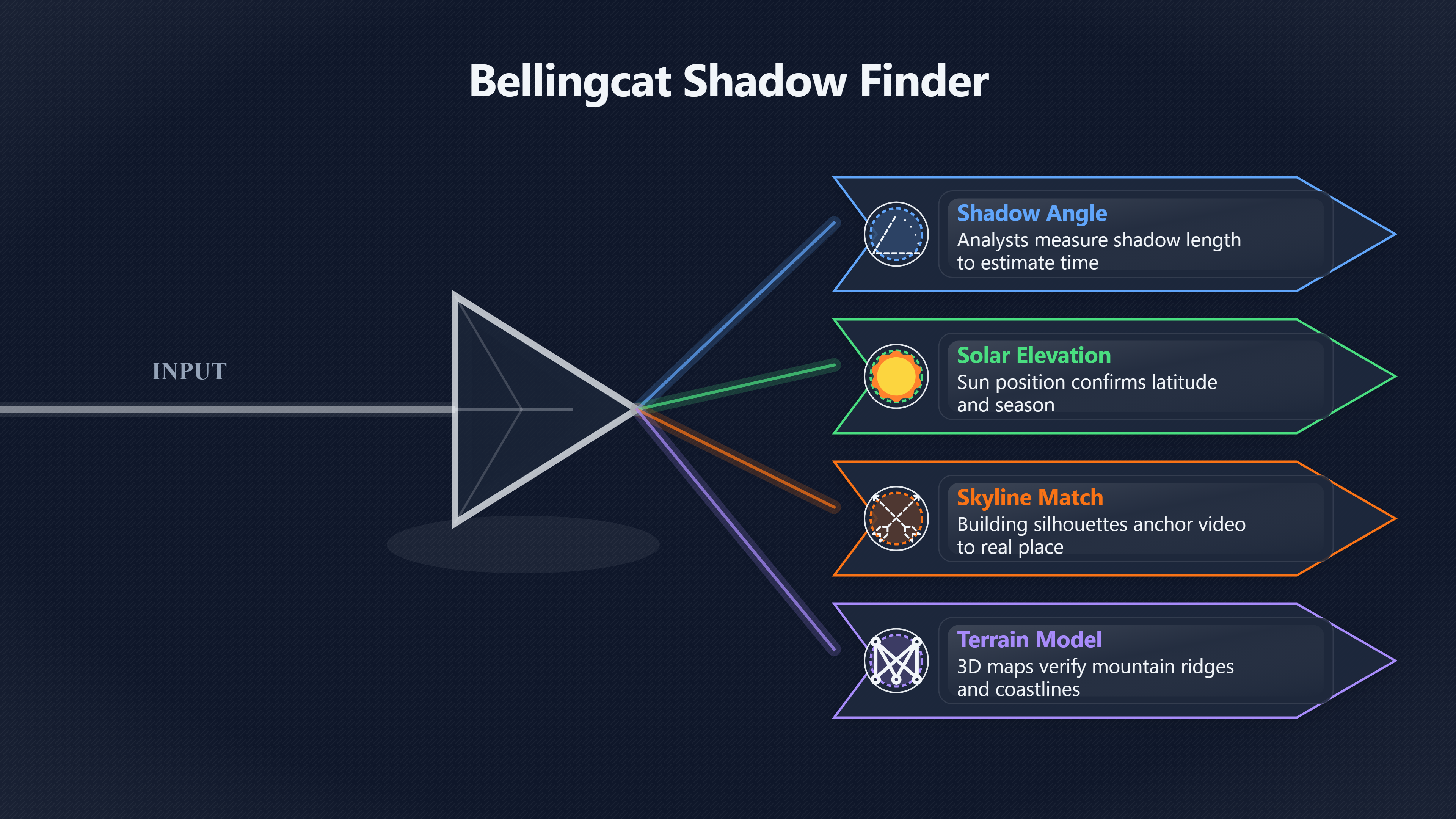
Using Weather and Shadows for Chronolocation
Geolocation and chronolocation usually work together. Even if investigators identify a likely filming area, the claimed time still needs verification.
Shadows are one of the strongest environmental clues available. Bellingcat and other open-source investigators regularly use sun position and shadow angle analysis to estimate where and when footage was captured. [bellingcat]bellingcat.comUnsure When a Video or Photo was Taken?How to Tell by…18 May 2021 — It's already well known that it's possible to use the angle of shadows to assess the time in an image. Su… [bellingcat]bellingcat.comsatellite imagery bands guideA Beginner's Guide to Seeing More With Satellite Imagery10 Jan 2025 — The simplest way to visualise these invisible bands of light is to…
Modern tools such as SunCalc and Bellingcat’s Shadow Finder allow analysts to compare: [bellingcat.gitbook.io]bellingcat.gitbook.ioBellingcat Shadow FinderBellingcatShadow Finder - Bellingcat's Online Investigation Toolkit2 Mar 2026 — Shadow Finder maps all points on the earth where a shadow…
- Shadow direction
- Shadow length
- Solar elevation
- Sunrise and sunset angles
- Seasonal sun position
against real astronomical conditions. [bellingcat]bellingcat.comChronolocation: Determining When a Photo was Taken…8 May 2023 — Bellingcat has used such chronolocation techniques to determine when u…
A UFO clip claiming to show a midnight sighting may immediately fail if the shadows clearly indicate low-angle evening sunlight. Likewise, footage said to be from northern Scotland may display sun geometry inconsistent with that latitude.
Clouds, haze and wind as location clues
Weather records are often underestimated in UFO investigation. Historical weather databases maintained by NOAA and other meteorological services can preserve detailed conditions for a specific date and location, including cloud cover, wind direction and visibility. NCEI [Open Meteo]open-meteo.comhistorical weather api️ Historical Weather APIHistorical 🌤️ weather data from 1940 onwards with weather records dating back to 1940 and hourly resolution avail…
Investigators compare these records against what appears in the footage:
- Were the clouds consistent with reported conditions?
- Did the moon phase match?
- Was there rain, haze or fog at the time?
- Did wind direction fit smoke or cloud movement?
- Were atmospheric conditions suitable for optical effects?
This can radically reshape a case.
A glowing stationary “craft” near the horizon, for example, may align perfectly with known atmospheric conditions that produce strong mirage effects or bright planetary distortion. Similarly, rapidly moving lights may correspond with low cloud reflections from aircraft or ground lighting.
AI-assisted systems can now automate portions of this correlation by cross-referencing timestamps with archived weather datasets and astronomical databases. However, the reliability still depends heavily on accurate input times and original footage integrity.

Stars, planets and aircraft corridors
Night footage introduces another layer of geolocation evidence: the sky itself.
Investigators increasingly use astronomy software to compare visible stars, planets and moon position against the claimed filming time and direction. A bright “hovering UFO” may align exactly with Venus, Jupiter or a known satellite pass once the camera orientation is reconstructed.
The same applies to aircraft routes. If geolocation places the witness beneath a known approach corridor, the probability of misidentified landing lights increases substantially.
This is where AI-assisted case reconstruction becomes particularly useful. Automated systems can combine:
- Terrain orientation
- Compass direction
- Celestial object databases
- Flight data
- Satellite tracking
- Historical weather [open-meteo.com]open-meteo.comhistorical weather api️ Historical Weather APIHistorical 🌤️ weather data from 1940 onwards with weather records dating back to 1940 and hourly resolution avail…
into a single timeline model.
The value is not that AI “solves” the sighting automatically, but that it rapidly tests whether the claimed context survives cross-checking.
How False Locations Reshape UFO Narratives
Some of the most dramatic UFO stories online depend entirely on location claims that later fail verification.
A clip presented as “secret military footage” may actually come from a public drone hobby area. A supposed offshore encounter may match a tourist viewpoint hundreds of miles away. Once the filming location changes, the interpretation of the object often changes with it.
This is one reason chain-of-custody problems matter so much. Viral reposting frequently disconnects footage from the original witness account, leaving investigators with:
- No confirmed filming position
- No reliable compass direction
- No exact timestamp
- No original metadata
- No uncompressed source file
At that point, even sophisticated AI analysis may rest on incorrect assumptions.

Recycled footage and false attribution
Geolocation work regularly exposes recycled UFO clips reused during later news cycles.
A common pattern looks like this:
- An older video is reposted with a new date and location
- Contextual details are removed
- The object is reframed as a recent unexplained event
- Social amplification spreads the claim faster than verification
Reverse image searching and frame comparison often reveal earlier uploads, but geolocation adds another layer by testing whether the visible environment even matches the claimed location. Amnesty International, WITNESS and Bellingcat all describe similar verification approaches in broader digital investigations. [Amnesty International]amnesty.orga guide to how amnesty verifies military attacks in ukraineGeo and chrono-location. Confirming where and when a video…Read more… [WITNESS Media Lab]lab.witness.orgWITNESS Media LabWITNESS Media Lab Verification ResourcesIt includes a step-by-step guide to verify and catalog online footage of human r…
In UFO communities, these corrections rarely travel as far as the original viral claim. A debunked location may receive little attention compared with dramatic speculation attached to the clip.
When geolocation fails
An important but often overlooked outcome is that some footage simply cannot be verified.
Citizen Evidence Lab has published discussions about “failed geolocation” cases where available clues were too limited or contradictory for confident conclusions. [Citizen Evidence Lab]amnesty.deCitizen Evidence LabDie US-Sektion von Amnesty hat ein Online-Tool entwickelt, mit dem Menschenrechtsorganisationen feststellen können, o…
That matters in UFO research because uncertainty is not proof of authenticity.
A genuinely unexplained clip may remain unverifiable because:
- The sky dominates the frame
- No terrain is visible
- Compression destroyed detail
- Weather obscures landmarks
- Metadata is absent
- Multiple edits exist online
- The original uploader disappeared
Responsible investigation separates:
- verified facts,
- inferred possibilities,
- plausible explanations,
- and unresolved unknowns.
A video that cannot be geolocated should not automatically be treated as extraordinary evidence. It simply occupies a weaker evidential category.
Why Geolocation Became Central to Modern UFO Investigation
Earlier UFO investigations often depended heavily on witness testimony alone. Modern digital investigations increasingly treat environmental verification as equally important.
That shift happened partly because open-source investigation techniques matured in journalism, conflict analysis and human rights work. Amnesty International, Bellingcat and related verification communities demonstrated that publicly available imagery could be rigorously checked using maps, satellite imagery, weather records and astronomical reconstruction. OUP Academic [Amnesty International]amnesty.orga guide to how amnesty verifies military attacks in ukraineGeo and chrono-location. Confirming where and when a video…Read more…
UFO investigators adopted many of the same methods because they answer practical questions quickly:
- Was the footage filmed where claimed?
- Did environmental conditions match? [ncei.noaa.gov]ncei.noaa.govNCEINational Centers for Environmental Information (NCEICenters for Environmental Information (NCEI) - NOAANOAA NCEI provides trusted environmental data about historical weather, climate, ocean…
- Could the object align with known air traffic?
- Did the sky orientation make sense?
- Was the timeline internally consistent?
In many cases, the result is not a dramatic revelation but a narrowing of possibilities. A location-confirmed video may still show an ordinary aircraft or atmospheric effect. But a location-failed video often loses much of its original narrative immediately.
That distinction is increasingly important in AI-assisted UFO sighting investigation. AI systems can accelerate comparison and correlation, but they cannot compensate for missing provenance or false context. Geolocation remains one of the clearest ways to test whether a UFO video belongs to the place and story attached to it online.
Endnotes
-
Source: bellingcat.com
Title: shadow geolocate geolocation locate image tool open source bellingcat measure
Link: https://www.bellingcat.com/resources/2024/08/22/shadow-geolocate-geolocation-locate-image-tool-open-source-bellingcat-measure/Source snippet
bellingcatGeolocate Images with Bellingcat's Shadow Finder Tool22 Aug 2024 — Bellingcat's new Shadow Finder Tool, developed with our Disc...
-
Source: amnesty.org
Title: a guide to how amnesty verifies military attacks in ukraine
Link: https://www.amnesty.org/en/latest/news/2022/03/a-guide-to-how-amnesty-verifies-military-attacks-in-ukraine/Source snippet
Geo and chrono-location. Confirming where and when a video...Read more...
-
Source: bellingcat.com
Title: using the sun and the shadows for geolocation
Link: https://www.bellingcat.com/resources/2020/12/03/using-the-sun-and-the-shadows-for-geolocation/Source snippet
bellingcatUsing the Sun and the Shadows for Geolocation3 Dec 2020 — SunCalc lets users analyse the position of shadows and the sun at any...
-
Source: bellingcat.com
Title: Unsure When a Video or Photo was Taken?
Link: https://www.bellingcat.com/resources/2021/05/18/unsure-when-a-video-or-photo-was-taken-how-to-tell-by-measuring-the-length-of-shadows/Source snippet
How to Tell by...18 May 2021 — It's already well known that it's possible to use the angle of shadows to assess the time in an image. Su...
Published: May 2021
-
Source: ncei.noaa.gov
Link: https://www.ncei.noaa.gov/cdo-web/Source snippet
ta in addition to station history information...
-
Source: open-meteo.com
Title: historical weather api
Link: https://open-meteo.com/en/docs/historical-weather-apiSource snippet
️ Historical Weather APIHistorical 🌤️ [weather data]({{ 'weather-data/' | relative_url }}) from 1940 onwards with weather records dating back to 1940 and hourly resolution avail...
-
Source: ncei.noaa.gov
Title: NCEINational Centers for Environmental Information (NCEI)
Link: https://www.ncei.noaa.gov/Source snippet
Centers for Environmental Information (NCEI) - NOAANOAA NCEI provides trusted environmental data about historical weather, climate, ocean...
-
Source: lab.witness.org
Link: https://lab.witness.org/portfolio_page/verification/Source snippet
WITNESS Media LabWITNESS Media Lab Verification ResourcesIt includes a step-by-step guide to verify and catalog online footage of human r...
-
Source: amnesty.org
Link: https://www.amnesty.org/en/latest/news/2018/09/digitally-dissecting-atrocities-amnesty-internationals-open-source-investigations/Source snippet
Amnesty InternationalAmnesty International's open source investigations26 Sep 2018 — Amnesty International has pioneered using open sourc...
-
Source: academic.oup.com
Link: https://academic.oup.com/jicj/article/21/4/661/7502637Source snippet
OUP AcademicExpert Evidence and Digital Open Source Informationby M Gillett · 2023 · Cited by 20 — This article examines how the Court ca...
-
Source: amnesty.org
Link: https://www.amnesty.org/en/latest/press-release/2019/12/amnesty-international-updates-citizen-evidence-lab-for-cutting-edge-open-source-human-rights-investigations/Source snippet
Amnesty International updates Citizen Evidence Lab for...11 Dec 2019 — It includes guides on tools and techniques to verify open source...
-
Source: amnesty.org
Link: https://www.amnesty.org/en/wp-content/uploads/2025/09/ASA3302062025ENGLISH.pdfSource snippet
devices being surveilled by unknown black ghosts with red eyes hovering...
-
Source: amnesty.org
Link: https://www.amnesty.org/ar/wp-content/uploads/2024/12/EUR7088132024ENGLISH.pdfSource snippet
“A DIGITAL PRISON”16 Dec 2024 — The Security Lab used digital forensic tools developed by Amnesty International, including the open-sourc...
-
Source: amnesty.de
Link: https://www.amnesty.de/tag/citizen-evidence-labSource snippet
Citizen Evidence LabDie US-Sektion von Amnesty hat ein Online-Tool entwickelt, mit dem Menschenrechtsorganisationen feststellen können, o...
-
Source: amnesty.de
Title: deutschland verbrechen am bildschirm aufdecken
Link: https://www.amnesty.de/informieren/amnesty-journal/deutschland-verbrechen-am-bildschirm-aufdeckenSource snippet
Verbrechen am Bildschirm aufdecken7 Dec 2020 — Das Evidence Lab hat auch Luftangriffe im Jemen oder Polizeigewalt in den USA untersucht...
-
Source: lab.witness.org
Title: ethical wednesdays when eyewitness footage cannot be verified
Link: https://lab.witness.org/ethical-wednesdays-when-eyewitness-footage-cannot-be-verified/Source snippet
Wednesdays: When Eyewitness Footage Cannot be...One of the greatest risks of using eyewitness videos in reporting is not understanding t...
-
Source: noaa.gov
Link: https://www.noaa.gov/education/resource-collections/climate/climate-data-monitoringSource snippet
A true color satellite image of North America with some cloud cover.Read more...
-
Source: bellingcat.com
Title: satellite imagery bands guide
Link: https://www.bellingcat.com/resources/2025/01/10/satellite-imagery-bands-guide/Source snippet
A Beginner's Guide to Seeing More With Satellite Imagery10 Jan 2025 — The simplest way to visualise these invisible bands of light is to...
-
Source: bellingcat.com
Link: https://www.bellingcat.com/resources/2023/05/08/chronolocation-determining-when-a-photo-was-taken-using-facebook-google-street-view-and-assorted-tiny-details/Source snippet
Chronolocation: Determining When a Photo was Taken...8 May 2023 — Bellingcat has used such chronolocation techniques to determine when u...
Published: May 2023
-
Source: citizenevidence.org
Link: https://citizenevidence.org/Source snippet
Citizen Evidence LabCitizen Evidence LabThe Evidence Lab is Amnesty International's digital investigations team, working to advance digit...
-
Source: bellingcat.gitbook.io
Title: quick geolocation search
Link: https://bellingcat.gitbook.io/toolkit/more/all-tools/quick-geolocation-searchSource snippet
BellingcatQuick geolocation search | Bellingcat's Online Investigation...Feb 22, 2026 — Quick Geolocation Search is a repository of vari...
-
Source: bellingcat.gitbook.io
Title: google earth pro
Link: https://bellingcat.gitbook.io/toolkit/more/all-tools/google-earth-proSource snippet
BellingcatGoogle Earth Pro | Bellingcat's Online Investigation ToolkitFeb 25, 2026 — It allows users to explore a 3D representation of th...
-
Source: citizenevidence.org
Title: geolocation through building panorama images
Link: https://citizenevidence.org/2019/12/10/geolocation-through-building-panorama-images/Source snippet
Citizen Evidence LabCreating a Panorama from a Video for Geolocation and...10 Dec 2019 — Tutorial on building a single panorama image fr...
-
Source: bellingcat.gitbook.io
Title: Bellingcat Shadow Finder
Link: https://bellingcat.gitbook.io/toolkit/more/all-tools/shadow-finderSource snippet
BellingcatShadow Finder - Bellingcat's Online Investigation Toolkit2 Mar 2026 — Shadow Finder maps all points on the earth where a shadow...
-
Source: citizenevidence.org
Link: https://citizenevidence.org/2021/12/10/not-everything-is-verifiable-but-thats-ok-lessons-from-a-failed-geolocation/Source snippet
Citizen Evidence LabNot Everything is Verifiable, But That's OK10 Dec 2021 — Not Everything is Verifiable, But That's OK: Lessons From a...
-
Source: citizenevidence.org
Title: Digital Verification Archives
Link: https://citizenevidence.org/category/method/digital-verification/page/2/Source snippet
Page 2 of 6How Amnesty's Digital Verification Corps documented the November 2019 protests in Iran · Ten questions we're asking about ethi...
Published: November 2019
-
Source: bellingcat.gitbook.io
Title: io Geolocation
Link: https://bellingcat.gitbook.io/toolkit/categories/geolocationSource snippet
Bellingcat's Online Investigation Toolkit - GitBook12 Mar 2026 — To analyse shadows in source imagery, Shadow Finder maps all points on t...
-
Source: amnesty.org.nz
Link: https://amnesty.org.nz/amnesty-international-updates-citizen-evidence-lab-cutting-edge-open-source-human-rights/Source snippet
ges, and highlights Amnesty International case studies showing how methodologies...Read more...
-
Source: medium.com
Link: https://medium.com/%40dam_coffee/bellingcat-challenge-up-the-creek-7b878568ad25Source snippet
Bellingcat Challenge: Up The Creek | by Dam CoffeeThis challenge was solved using both metadata and visual geolocation. First, extracting...
-
Source: scribd.com
Link: https://www.scribd.com/document/784989239/Bellingcat-s-Online-Investigation-ToolkitSource snippet
, websites to archive web pages, and much more.Read more...
Additional References
-
Source: linkedin.com
Link: https://www.linkedin.com/posts/bellingcat_how-to-find-a-location-using-only-the-shadow-activity-7278001752497373184-EPzmSource snippet
how to find a location using only the shadow | BellingcatA tool that will let you put in the length of a shadow and get a bunch of locati...
-
Source: github.com
Link: https://github.com/bellingcat/toolkit/blob/main/gitbook/tools/shadow-finder/README.mdSource snippet
toolkit/gitbook/tools/shadow-finder/README.md at mainTo analyse shadows in source imagery, Shadow Finder maps all points on the earth whe...
-
Source: hertie-school.org
Title: workshop open source investigation for human rights ethics methods and practices
Link: https://www.hertie-school.org/en/news/allcontent/detail/content/workshop-open-source-investigation-for-human-rights-ethics-methods-and-practicesSource snippet
Workshop: Open-source investigation for human rights17 Feb 2020 — The demonstrators presented case studies showing how methodologies such...
-
Source: factcheckni.org
Title: digital verification for human rights amnesty international imaginebelfast
Link: https://factcheckni.org/articles/news/digital-verification-for-human-rights-amnesty-international-imaginebelfast/Source snippet
Digital verification for human rights: Amnesty International...28 Mar 2019 — Citizen Evidence Lab is an online space created by Amnesty...
-
Source: youtube.com
Link: https://www.youtube.com/shorts/X4ttdyrF7ocSource snippet
Simplify Geolocation with Bellingcat's Shadow Finder ToolBellingcat's Shadow Finder Tool simplifies geolocation by analyzing shadows. Usi...
-
Source: youtube.com
Link: https://www.youtube.com/watch?v=8RRF45BTy-8 -
Source: climate.gov
Link: https://www.climate.gov/maps-data/climate-data-primer/how-do-weather-observations-become-climate-dataSource snippet
How do weather observations become climate information?Once weather data has passed quality control, it becomes part of the larger data r...
-
Source: spaceweather.gov
Title: 43 years solar synoptic maps featured video slatecom
Link: https://www.spaceweather.gov/news/43-years-solar-synoptic-maps-featured-video-slatecomSource snippet
43 Years of Solar Synoptic Maps featured in video on Slate...21 Sept 2015 — Slate.com posted a video showcasing each hand-drawn Solar Sy...
-
Source: humanrights.berkeley.edu
Title: Evidence Lab’s geolocation of a video of an incident in Mahbere
Link: https://humanrights.berkeley.edu/wp-content/uploads/2024/05/Guide-for-judges.pdfSource snippet
Berkeley Human Rights CenterEvaluating digital open source imagery: A guide for judges...24 May 2024 — Figure F: Terrain mapping example...
Published: May 2024
-
Source: visualcrossing.com
Link: https://www.visualcrossing.com/Source snippet
queries using global historical, real-time, and forecast data from trusted sources...Read more...
Amazon book picks
Further Reading
Books and field guides related to Did This UFO Video Really Come From Here?. Use these as the next step if you want deeper reading beyond the article.
eBay marketplace picks
Marketplace Samples
Example marketplace items related to this page. Use the search link to explore similar finds on eBay.
![Listing image for UFO PHOTO [MICHAEL SCHENKER] 1970`S TOUR BLACK WHITE IMAGE HEAVY METAL ROCK GEM](/assets/images/marketplace-covers/4d004612d84842389376.jpg)

Topic Tree