Within Tracker gaps
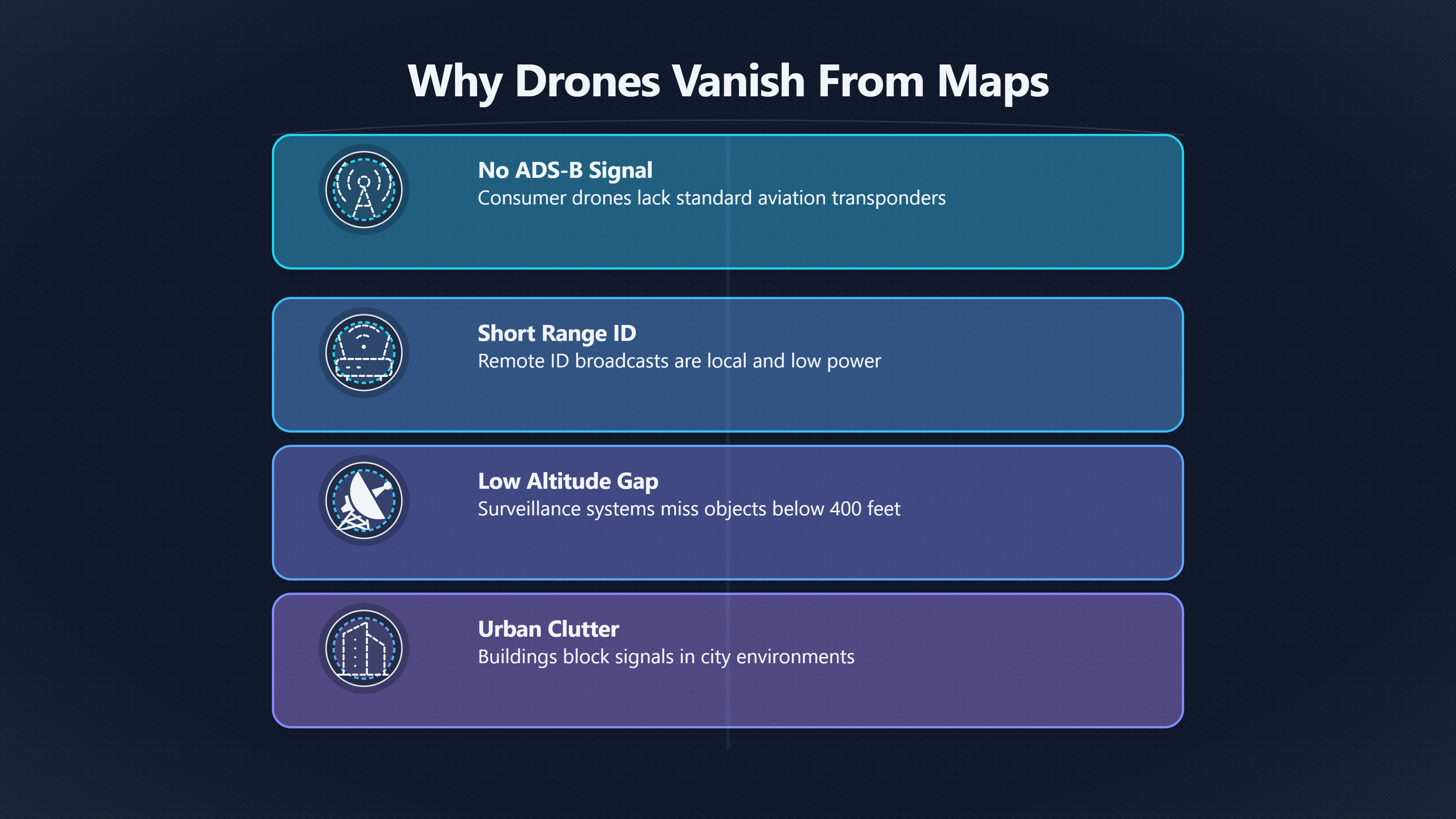
Why Public Trackers Miss So Many Drones
Most consumer drones leave little or no visible trace on mainstream aviation tracking services despite legal operation.
On this page
- Why consumer drones lack public tracks
- Remote ID limits and fragmented coverage
- Drone sightings mistaken for anomalous lights
Page outline Jump by section
Introduction
A drone can be flying legally, brightly lit and clearly visible to witnesses while leaving little or no trace on the public flight maps that people commonly check after a UFO or UAP sighting. This is one of the biggest misunderstandings in modern sighting analysis. Many people assume that if nothing appears on a service such as Flightradar24, ADS-B Exchange or FlightAware, then no aircraft was present. In reality, most small drones are not designed to appear on those systems in the first place. [Federal Aviation Administration]faa.govFederal Aviation Administration What is ADS-B?Federal Aviation Administration What is ADS-B? [2Flightradar24]flightradar24.comHow it worksADS-B technology is the long-term air traffic management replacement for radar technologies, especially in areas with limited…
 For AI-assisted UFO investigation, this matters because drones can create some of the most confusing night-time sightings: hovering lights, abrupt direction changes, silent motion, apparent stationary objects and unusual colour patterns. A missing public flight track therefore does not rule out a drone explanation. Instead, investigators need to understand how drone tracking actually works, what data is publicly visible, and where the gaps remain.
Why consumer drones usually never reach public flight maps
Most public flight trackers were built around conventional aviation. Their core systems depend on aircraft broadcasting ADS-B, a radio-based position reporting system used by airliners and many larger aircraft. Consumer drones generally do not transmit ADS-B position data in the same way, and in some jurisdictions routine ADS-B broadcasting from drones is discouraged or restricted because of concerns about overwhelming aviation surveillance networks. [MDPI]mdpi.com2504 446XThe Legacy of ADS-B, New Establishment of Remote ID, or…by N Ruseno · 2022 · Cited by 49 — One of the concerns from the aviation commu… [Federal Aviation Administration]faa.govFederal Aviation Administration What is ADS-B?Federal Aviation Administration What is ADS-B? [3Flightradar24]flightradar24.comHow it worksADS-B technology is the long-term air traffic management replacement for radar technologies, especially in areas with limited…
That creates a basic visibility gap. A typical consumer quadcopter flying below 400 feet may be entirely absent from the feeds that power mainstream aviation maps. Even where a drone carries some form of electronic identification, it may be using a completely different system from the one public trackers are designed to ingest.
In practical UFO casework, this means a witness can honestly report:
- no aircraft noise
- no visible plane on a tracker
- unusual hovering or lateral movement
- bright navigation lights at low altitude
and still have observed a perfectly ordinary drone.
The problem becomes more pronounced in urban areas at night, where depth perception is poor and drones can appear much farther away than they really are. A drone only a few hundred metres from a witness can seem like a distant object high in the sky, especially if viewed against darkness or cloud.
Remote ID is not the same as ADS-B
A major source of confusion comes from the assumption that drone “Remote ID” works like public aircraft tracking. It does not.
Remote ID systems were introduced mainly to help regulators and nearby authorities identify drones locally. In the United States, the FAA describes Remote ID as a broadcast system for unmanned aircraft rather than a direct extension of the standard ADS-B network used by conventional aviation. [Federal Aviation Administration]faa.govFederal Aviation Administration What is ADS-B?Federal Aviation Administration What is ADS-B? [Federal Register]federalregister.govremote identification of unmanned aircraft systems31 Dec 2019 — This proposed rule would provide remote identification of UAS in the airspace of the United States to address safety, secur…
Most Remote ID implementations use short-range radio methods such as Wi-Fi or Bluetooth broadcasts rather than long-range aviation transponders. As a result:
- the signal range is limited
- reception is highly localised
- many public aviation sites do not ingest the data
- coverage depends on nearby compatible receivers
This is why a drone may technically be broadcasting identification data while remaining invisible on mainstream flight maps. Several drone-tracking applications exist, but they usually detect only nearby Remote ID broadcasts rather than feeding a global public air-traffic network. [Reddit]reddit.comLike Flightradar24…: r/dronesRedditLike Flightradar24…: r/dronesOctober 17, 2024 — There is DroneScanner by Dronetag (aka the Karen app) but it only shows drones in…
For UFO investigations, the practical implication is important: “the drone should have shown up” is often based on a misunderstanding of how drone identification systems are separated from public aircraft tracking infrastructure.
Remote ID coverage is fragmented and incomplete
Even where Remote ID rules exist, coverage is patchy.
A drone’s identification signal normally has to be physically received by equipment within radio range. Unlike airliner ADS-B signals, which can be collected by large distributed receiver networks over long distances, many drone Remote ID broadcasts are short-range and low power. Buildings, terrain and interference can block them easily.
That creates several investigative problems:
Public access is inconsistent
Some jurisdictions require drones to broadcast identification data, but there may be no public map that aggregates the information nationwide. Reports from drone industry observers and FAA-focused coverage note that there is still no equivalent of a universal “Flightradar24 for drones”. [Reddit]reddit.comRedditCan someone explain this new regulation to me like I'm 5September 10, 2023 — If you have a DJI Mini 3 Pro or a drone 249 grams or u…
In other words, the data may exist locally without being publicly searchable afterwards.
Small drones may be exempt
Certain lightweight drones fall below registration or Remote ID thresholds in some countries. Discussions around FAA implementation repeatedly note exemptions for sub-250-gram aircraft in many recreational scenarios. [Reddit]reddit.comheir ADSB transponders and these "images" and not actual A/C appear…Read more…
This matters because many popular consumer drones are deliberately designed around these weight limits.
Operators can still disappear from public view
Even where regulations require broadcasting, visibility depends on:
- compatible receiving hardware nearby
- functioning firmware
- signal propagation
- local data-sharing policies
- whether the feed is made public at all
An investigator checking only commercial flight websites may therefore see nothing even during heavy low-altitude drone activity.
Why low-altitude drones are especially hard to detect
Public aircraft tracking systems work best with aircraft flying high and transmitting strongly. Consumer drones operate in almost the opposite environment.
[Typical drone operations involve:]faa.govUnmanned Aircraft System Traffic Management (UTMMay 2, 2025 — UTM is a collaborative ecosystem for safely managing unmanned aircraft (UA or drone) operations at low altitudes.Read more…
- low altitude [dronelife.com]dronelife.comLow Altitude Airspace Awareness Closing the GapsDRONELIFELow Altitude Airspace Awareness Closing the GapsJanuary 15, 2025 — 15 Jan 2025 — For those of us involved with autonomous aviati…
- short range
- urban clutter
- intermittent movement
- hovering
- local radio interference
These conditions reduce visibility to traditional aviation surveillance systems. Low-altitude airspace has long been recognised as a difficult surveillance environment even beyond hobby drones. Industry commentary on unmanned traffic management repeatedly highlights the limits of existing radar, ADS-B and Remote ID systems for small low-flying aircraft. [DRONELIFE]dronelife.comLow Altitude Airspace Awareness Closing the GapsDRONELIFELow Altitude Airspace Awareness Closing the GapsJanuary 15, 2025 — 15 Jan 2025 — For those of us involved with autonomous aviati…
For UFO analysis, this explains a common pattern:

- Witness sees a hovering or manoeuvring light.
- Witness checks a flight tracker.
- Tracker appears empty.
- Witness concludes the object was not an aircraft.
But the tracker may simply have no meaningful visibility into the relevant layer of low-altitude airspace.
Why drone sightings can look genuinely strange
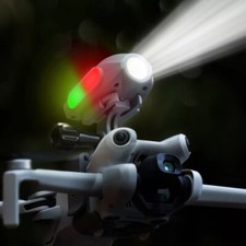
Modern drones are unusually effective at generating “anomalous” visual impressions.
Even ordinary consumer models can produce:
- stationary hovering lights
- rapid acceleration
- sudden vertical climbs
- smooth lateral movement
- silent or near-silent operation at distance
- bright LEDs with poor depth cues
- apparent disappearance when lights turn off or rotate away
At night, these effects become exaggerated. Witnesses often struggle to estimate altitude, distance and speed accurately without familiar size references.
A drone flying directly towards an observer may appear almost motionless for long periods. A drone turning sideways can suddenly appear to “shoot off” because the navigation lights change orientation. Multiple drones flying coordinated routes can resemble formations of unknown objects.
This does not mean every unexplained sighting is a drone. It does mean drone behaviour overlaps strongly with the visual characteristics commonly reported in UFO cases.
AI-assisted investigation workflows should treat drone absence cautiously
An effective AI-assisted UFO investigation workflow should not ask only “Was a drone track visible?” It should ask a broader set of questions:
- Was the sighting location inside a likely drone-use area?
- Was it near parks, coastlines, events or residential zones?
- Did the object remain below typical aircraft altitude?
- Did the witness report hovering or stop-start movement?
- Were there local restrictions that might affect legal drone use?
- Was Remote ID coverage even available nearby?
- Was the time period associated with known drone activity spikes?
AI systems can help by correlating sightings with:
- local drone regulations
- NOTAMs and temporary flight restrictions
- known photography hotspots
- urban density
- social media reports
- prior drone-related incidents
- weather conditions favourable for drone flight
But the workflow should avoid treating public tracker absence as hard exclusion evidence.
A useful investigative distinction is:
- No public aircraft track found
- versus
- Strong evidence no conventional aircraft or drone was present
Those are not the same conclusion.

The public expectation gap around drone visibility
One reason drone sightings create confusion is that the public now expects complete airspace transparency. People are used to opening an app and seeing nearby passenger aircraft instantly. That creates an understandable assumption that “everything flying” should appear too.
In reality, public airspace visibility is fragmented across several different systems:
- commercial aviation ADS-B
- military and filtered aviation feeds
- glider and FLARM networks
- local radar coverage [flightradar24.com]flightradar24.comHow it worksADS-B technology is the long-term air traffic management replacement for radar technologies, especially in areas with limited…
- Remote ID broadcasts
- proprietary drone detection systems
- law-enforcement-only tools
These systems do not combine neatly into one universal public map.
Some specialised drone-detection platforms can integrate radio-frequency interception, Remote ID and other cooperative signals, but these are typically commercial or governmental systems rather than public consumer services. [SkeyDrone Support]support.skeydrone.aeroCritical for detecting unauthorized or malicious drones.Read moreSkeyDrone SupportWhat types of drone detections does Drone Radar…Can detect position, altitude, and sometimes serial number, even if R…
For UFO investigators, this means an apparently empty sky on a public tracker should be treated as incomplete evidence rather than definitive proof.
The key takeaway for UFO case analysis
The absence of a drone on a public flight tracker is usually weak evidence, not strong evidence.
Most consumer drones were never designed to appear reliably on mainstream aviation maps. Remote ID systems are fragmented, local and often inaccessible to the public. Low-altitude flight conditions further reduce visibility. Small drones may also operate under exemptions or outside integrated public tracking networks altogether. [MDPI]mdpi.com2504 446XThe Legacy of ADS-B, New Establishment of Remote ID, or…by N Ruseno · 2022 · Cited by 49 — One of the concerns from the aviation commu… [Federal Aviation Administration]faa.govFederal Aviation Administration What is ADS-B?Federal Aviation Administration What is ADS-B? [Federal Aviation Administration]faa.govFederal Aviation Administration What is ADS-B?Federal Aviation Administration What is ADS-B?
In AI-assisted UFO investigation, the better approach is not to treat empty tracker maps as proof of anomaly, but to combine them with altitude estimates, witness geometry, environmental conditions, local drone-use likelihood and other contextual evidence. A missing track may narrow possibilities slightly, but by itself it rarely rules drones out.
Endnotes
-
Source: faa.gov
Title: Federal Aviation Administration What is ADS-B?
Link: https://www.faa.gov/faq/what-ads-b-will-ads-b-be-required-small-uas-or-drones-future -
Source: flightradar24.com
Link: https://www.flightradar24.com/how-it-worksSource snippet
How it worksADS-B technology is the long-term air traffic management replacement for radar technologies, especially in areas with limited...
-
Source: mdpi.com
Title: 2504 446X
Link: https://www.mdpi.com/2504-446X/6/3/57Source snippet
The Legacy of ADS-B, New Establishment of Remote ID, or...by N Ruseno · 2022 · Cited by 49 — One of the concerns from the aviation commu...
-
Source: faa.gov
Title: remote id
Link: https://www.faa.gov/uas/getting_started/remote_idSource snippet
Federal Aviation AdministrationRemote Identification of Drones19 Mar 2025 — Some drone operators may be eligible to operate without Remot...
-
Source: reddit.com
Title: Like Flightradar24…: r/drones
Link: https://www.reddit.com/r/drones/comments/1g5yie7/like_flightradar24/Source snippet
RedditLike Flightradar24…: r/dronesOctober 17, 2024 — There is DroneScanner by Dronetag (aka the Karen app) but it only shows drones in...
Published: October 17, 2024
-
Source: reddit.com
Link: https://www.reddit.com/r/drones/comments/16faswy/can_someone_explain_this_new_regulation_to_me/Source snippet
RedditCan someone explain this new regulation to me like I'm 5September 10, 2023 — If you have a DJI Mini 3 Pro or a drone 249 grams or u...
Published: September 10, 2023
-
Source: dronelife.com
Title: Low Altitude Airspace Awareness Closing the Gaps
Link: https://dronelife.com/2025/01/15/closing-the-gaps-why-low-altitude-airspace-awareness-is-critical-for-the-future-of-aviation/Source snippet
DRONELIFELow Altitude Airspace Awareness Closing the GapsJanuary 15, 2025 — 15 Jan 2025 — For those of us involved with autonomous aviati...
Published: January 15, 2025
-
Source: support.skeydrone.aero
Title: Critical for detecting unauthorized or malicious drones.Read more
Link: https://support.skeydrone.aero/portal/en/kb/articles/what-types-of-drone-detections-does-drone-radar-support-e-g-ads-b-remote-id-rfSource snippet
SkeyDrone SupportWhat types of drone detections does Drone Radar...Can detect position, altitude, and sometimes serial number, even if R...
-
Source: reddit.com
Link: https://www.reddit.com/r/ADSB/comments/vqwd6k/is_anyone_in_the_us_seeing_drones_with_icao_hex/Source snippet
heir ADSB transponders and these "images" and not actual A/C appear...Read more...
-
Source: reddit.com
Link: https://www.reddit.com/r/UAP/comments/1hmf4pr/they_say_that_what_we_are_seeing_do_consist_of/Source snippet
flight tracker apps like flightradar24, or...Read more...
-
Source: reddit.com
Link: https://www.reddit.com/r/ADSB/comments/kn8584/faa_most_commercial_drone_flights_must_not_use/ -
Source: faa.gov
Title: Limiting Aircraft Data Displayed (LADD)
Link: https://www.faa.gov/pilots/laddSource snippet
May 1, 2025 — "Unblocking" will ensure aircraft flight data will be included in the FAA data feed utilized by participating internet flig...
Published: May 1, 2025
-
Source: faa.gov
Link: https://www.faa.gov/air_traffic/technology/equipadsb/privacySource snippet
ADS-B PrivacyMar 22, 2025 — Email confirmation of your third-party flight ID to adsbprivacyicao@faa.gov. This can be an email or scanned...
-
Source: faa.gov
Title: Unmanned Aircraft System Traffic Management (UTM)
Link: https://www.faa.gov/uas/advanced_operations/traffic_managementSource snippet
May 2, 2025 — UTM is a collaborative ecosystem for safely managing unmanned aircraft (UA or drone) operations at low altitudes.Read more...
Published: May 2, 2025
-
Source: uavionix.com
Link: https://uavionix.com/blog/industry-view-failure-of-remote-id-in-nj-might-have-cost-us-years/?srsltid=AfmBOooigpydfZb41bArxHEGGJqGmr2CXbdrF1G4a8vcB-Rtkx8Ue0dESource snippet
Industry View: Failure of Remote ID in NJ Might Have Cost...18 Feb 2025 — It is the “digital license plate” system that the FAA establis...
-
Source: mavicpilots.com
Title: flightradar24 able to display uavs.137623
Link: https://mavicpilots.com/threads/flightradar24-able-to-display-uavs.137623/Source snippet
DJI Mavic, Air & Mini Drone CommunityFlightradar24 able to display UAVs | DJI Mavic, Air & Mini...13 May 2023 — ADSB out is not allowed...
Published: May 2023
-
Source: federalregister.gov
Title: remote identification of unmanned aircraft systems
Link: https://www.federalregister.gov/documents/2019/12/31/2019-28100/remote-identification-of-unmanned-aircraft-systemsSource snippet
31 Dec 2019 — This proposed rule would provide remote identification of UAS in the airspace of the United States to address safety, secur...
Additional References
-
Source: infrastructure.gov.au
Link: https://www.infrastructure.gov.au/sites/default/files/documents/adsb-101-anonymous.pdfSource snippet
AnonymousFor flights operated under VFR, a broader range of ADS-B OUT options are useable: • for the rare high-level operation (e.g. high...
-
Source: committees.parliament.uk
Link: https://committees.parliament.uk/writtenevidence/101442/pdf/Source snippet
on Commercial and recreational drone use in the...A cut-off point should be set, with especially low mass, airspeed and command link ran...
-
Source: youtube.com
Link: https://www.youtube.com/watch?v=JeEohJoGAXwSource snippet
ADS-B for Drones: Why airplanes don't always show upIn this video, we discuss the manned aircraft technology known as ADS-B. It is often...
-
Source: aeromind.pl
Title: Everything you should know about Remote ID blog eng 1677159185
Link: https://aeromind.pl/Everything-you-should-know-about-Remote-ID-blog-eng-1677159185.html?srsltid=AfmBOoomqZzVyDAGcPdM9fHNao_tPhr4fo0dwv65nAFT8tv-XtOmQ_aLSource snippet
Everything you should know about Remote ID23 Feb 2023 — Today, the writing on the box: ADS-B compliant unfortunately does not take care o...
-
Source: osintteam.blog
Title: OSINT Team’Flight radar app’ for civilian drones?
Link: https://osintteam.blog/flight-radar-app-for-civilian-drones-yes-and-no-4249122392fcSource snippet
Yes and No. - OSINT Team3 Jan 2026 — The Only Methods to Avoid Tracking: Fly a drone under 250g in the US or under 100g in Japan, as thes...
-
Source: facebook.com
Link: https://www.facebook.com/groups/218676792817854/posts/1087935675891957/Source snippet
Example: (1) attached photo, “ Unmanned Aircraft” from surface to 10,000ft...
-
Source: thedronegirl.com
Link: https://www.thedronegirl.com/2025/02/11/how-track-drones-flying-near-me/Source snippet
The Drone GirlHow can I track drones flying near me?Jan 30, 2025 — Right now, that information isn't available in a public website like F...
-
Source: caa.co.uk
Link: https://www.caa.co.uk/drones/open-category/drone-code/where-you-can-fly-points-3-to-9/Source snippet
surface. If you fly where the ground falls or rises...Read more...
-
Source: uavionix.com
Title: the case for low power ads b for drones
Link: https://uavionix.com/blog/the-case-for-low-power-ads-b-for-drones/?srsltid=AfmBOooo5YbCSA09oO9LlOKeHUnwLdsxCBE40srOvQSVon-JQicB0LnOSource snippet
The Case for Low Power ADS-B for Drones29 Jan 2017 — It is legal to broadcast ADS-B from drones today from 7-350 Watts – contributing to...
-
Source: jrupprechtlaw.com
Link: https://jrupprechtlaw.com/ultimate-guide-to-handling-unidentified-drone-sightings-civilians-law-enforcement-etc/Source snippet
See 14 CFR Part 89. However, there are SOME aircraft that...
Amazon book picks
Further Reading
Books and field guides related to Why Public Trackers Miss So Many Drones. Use these as the next step if you want deeper reading beyond the article.
eBay marketplace picks
Marketplace Samples
Example marketplace items related to this page. Use the search link to explore similar finds on eBay.

Topic Tree